
Parade route and street map
The parade starts at the corner of Proctor and 4th Avenue and travels down Oliver Street through downtown Williams Lake.
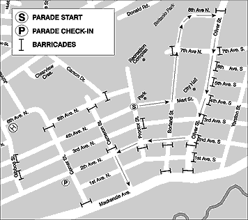
Route at a glance
- Starts
- Proctor & 4th Avenue
- Main street
- Oliver Street
- Entrant check-in
- Comer & 2nd Avenue
- Step-off time
- 10:00 a.m.
How the route works
Entries stage near Comer and 2nd Avenue, where marshals check them in from 7:00 a.m. and judging closes at 8:00 a.m. precisely. From staging, entries move into position and the parade steps off at the corner of Proctor and 4th Avenue, then proceeds along Oliver Street in front of the downtown crowds.
Because the route runs through the heart of downtown, most of the best viewing is kerbside along Oliver Street and at the cross-streets that meet it.
Planning to cross the route? Streets on the route close for the duration of the parade. Cross before 10:00 a.m. or wait until the last entry has passed — marshals and the Harley Owners Group (HOG) security riders will let you know when it is safe.
Entries that travel the route
More than 140 entries take part each year, grouped into seven judged classifications.
| # | Classification | Typical entries |
|---|---|---|
| 1 | Equine | Dressed cowboys and cowgirls, horse groups, buggy and wagon entries |
| 2 | Floats | Municipal, commercial, comic, youth and community group floats |
| 3 | Bands | Conventional, marching and community bands |
| 4 | Youth | Entries from participants aged 12 and under |
| 5 | Automotive | Antique and classic cars and trucks, plus specialty vehicles |
| 6 | Mascots and clowns | Mascots, clowns and comic characters |
| 7 | Best theme entry | Entries that best interpret that year's parade theme |